- Date
- vendredi 9 décembre 2022
- Auteur
- Ryan Buhler, Forecast Program Supervisor
Conditions in the interior of BC are tricky right now. Frigid arctic air back in November left us with a widespread persistent weak layer and although avalanche activity on this layer has so far been sporadic, it may increase with new snow, wind, or warming. If you are planning on heading out this weekend, it will be important to be aware of this persistent weak layer and have a conservative mindset.
The Snowpack
The cold Arctic air had two major impacts on the early season snowpack. First, depending on your location, it formed at least one well-developed persistent weak layer which was buried between November 17 and 22 (referred to as the mid-November weak layer). It can easily be observed within the snowpack and has resulted in many observations of whumpfing, shooting cracks, and remotely triggered avalanches, throughout the interior. We have lots of evidence of snowpack test results suggesting that this layer has a propensity for easy triggering and propagation, making it a ‘yellow flag’ to be aware of. However, we aren’t yet seeing the amount of avalanche activity this might suggest. This isn’t because this layer isn’t unstable, but rather because the snow above it has not formed a slab… yet.
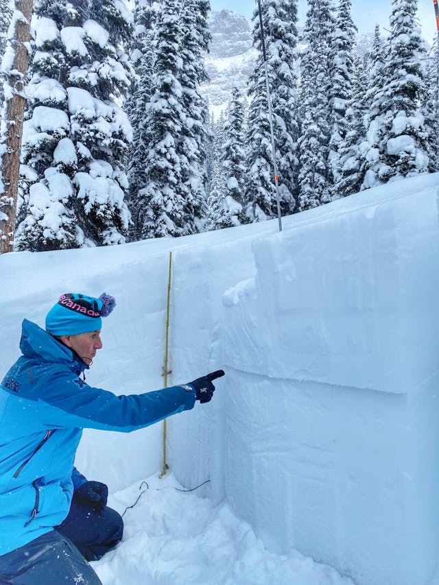
A snow profile from the Mear Lake area north of Fernie shows the mid-November weak layer is reactive and suggests that propagation would be likely if a cohesive slab was present. Photo: South Rockies Field Team
Where’s the Slab?
The existence of a highly reactive weak layer on its own is not enough to create a persistent slab problem that elevates avalanche danger. A persistent slab problem requires both a persistent weak layer and a cohesive slab on top of it. This brings me to the second condition caused by the extended periods of cold arctic air and a generally shallow early-season snowpack—an apparent lack of slab formation in many parts of the interior. Because of the prolonged cold conditions, the recent storm snow has not settled in many areas and may even be doing the opposite. The entire relatively shallow snowpack may be undergoing faceting in some regions. This is keeping the snowpack unconsolidated and prevents the formation of a cohesive slab.
We know there is a widespread weak layer throughout the interior, and therefore we would expect avalanches to be possible anywhere that a slab has formed. But the ongoing cold conditions mean it is difficult to know where slabs may exist.
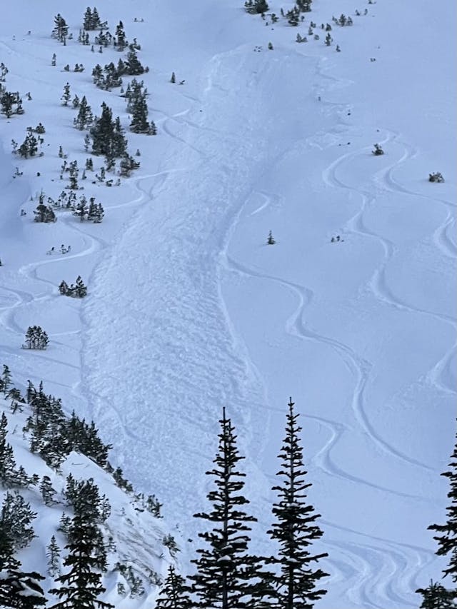
An example of the type of smaller avalanches we have been seeing a lot recently. As the slab becomes more cohesive, we expect the size of these slabs to become larger and propagate more widely. Photo: Skiing Golden, submitted to the MIN
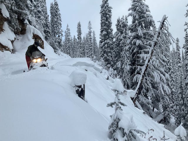
An example of remote triggering, with the slope being triggered from the adjacent flat terrain. At this location/elevation, the slab may not be thick enough or cohesive enough to form a destructive slab, but this is a strong sign that the layer may be capable of producing large avalanches where the slab is thicker or more cohesive, such as at higher elevations or in more wind loaded terrain. Photo: Blaseror, submitted to the MIN
The Tipping Point
We commonly refer to the period where loose surface snow transitions into a reactive slab as ‘the tipping point’. There are several conditions that may cause the current loose surface snow to transition to a reactive slab including:
- A major storm system bringing a substantial amount of new load over the weak layer.
- Wind events loading leeward features.
- A warming event or extended periods of solar radiation on steep sun-exposed slopes.
- A combination of slow snow accumulation with an extended period of milder temperatures.
We have seen a few of these conditions, especially wind loading, result in some large avalanches over the past couple of weeks. Wind loading has also been one of the main messages in our bulletins recently. Although we’re not expecting substantial warming, just a few hours of sun on steep sun-exposed slopes can be a major player in the likelihood of triggering an avalanche, as the example below shows.
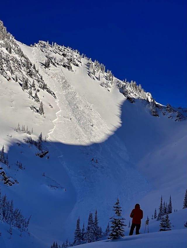
A period of sun caused enough warming for the upper snowpack to settle into a slab resulting in this avalanche on a SW aspect which failed on the mid-November layer. This is a good example of the type of avalanche we would expect where a slab can be found above the weak layer from mid-November. Photo: Mikey, submitted to the MIN
For now and in the immediate future, we likely can expect danger to remain elevated as slabs form over the buried weak layer. It will be important to watch carefully for any signs that the upper snowpack is settling into a slab and ensure your plans match the conditions.
For more details on persistent slab problems, check out the video about Persistent Slabs on Avy Savvy.