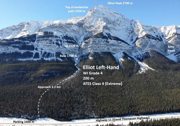
Elliot Left-Hand
200 m, WI 4
ATES 4 (Extreme)
Elliot Left-Hand is a high-quality ice climb located on the east face of Elliot Peak, 36 km east of the Saskatchewan River Crossing on Highway 11, known as the David Thompson Highway. It’s essential to note that Elliot Left-Hand has significant overhead avalanche hazard, as it climbs inside a narrow gully/canyon located in the centre flow line of the avalanche path and all avalanches starting from above funnel through here.
Accordingly, this climb requires careful consideration of avalanche conditions, with a preference for low avalanche danger. Additionally, aiming for a cool or overcast day is advisable, as the upper slopes get the morning sun.

Popularity
- 25 people completed the survey
- 56% climbed Elliot Left-Hand once
- 36% climbed it 2-5 times
- 8% climbed it over 6 times
Avalanche Frequency
- 68% have seen avalanche debris on the climb or the approach
- 32% have not seen any avalanche debris
- 9% have witnessed an avalanche in the area
Avalanche Runout
- 60% saw avalanche debris on the approach
- 73% saw debris at the base of the climb or lower
- 67% saw debris between the pitches
- 3% saw debris above the last pitch
Notes on Avalanche Debris
- Many people noted debris far down the gully, 200 m below the climb.
- One respondent remembers seeing debris from a size 3 avalanche that ran 100 m past the beginning of the climb. The debris was 2 to 3 m deep.
- Another respondent recalls seeing debris at the base of the climb from an avalanche that ran from climber’s left. The debris stopped just short of the climb.
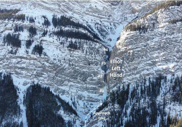
- Multiple people noted seeing avalanche debris from the approach gully where you exit out of the trees to the base, after the first pitch to the crux pitch.
- There are piles of debris up to 2 m in depth well into the runout zone every year.
- One respondent mentioned that they observed avalanche debris from multiple small avalanches (up to size 2) from the sidewalls and slopes between pitches.
Avalanche Start Zones
- 40% believe the observed avalanche started well above the climb
- 60% were unsure where the observed avalanche started
Contributing Factors
- 50% were attributed to winds
- 33% were attributed to significant warming or solar radiation
- 33% were attributed to new snow amounts
Reported Avalanches and Incidents
- One respondent climbed Elliot Left-Hand as a guided climb in 1999 on a day when avalanche conditions were rated as low/low/low with good stability. However, as the wind picked up, the group was unexpectedly struck by a size 2 avalanche while on the first pitch.
Summary
- Avalanches have been known to run all the way through the canyon with formidable force. On one occasion, I found myself using a thigh-sized snapped-off log in avalanche debris to build an anchor because not much else was around. I anticipate that the starting zones will be similar-ish sized as above kitty hawk. C'est La Vie (positioned between Kitty Hawk and Elliot Left-Hand) might not be a popular climb but is still in big terrain. Friends (one IFMGA Guide) witnessed a size 3 avalanche on this route.
- This route pulls more often than Kitty Hawk, slightly smaller more regular events.
- The terrain surrounding this route is prone to frequent slides. Although major avalanches are somewhat infrequent most years due to relatively low snow accumulation.
- A huge bowl is situated directly above the climb, with another bowl above that. There are sparse, younger trees closer to the run and unaffected trees on the east side of the slopes. Despite searching, I couldn’t locate rap rings; I left a sling around a tree for rappelling.