- Date
- Tuesday, April 18, 2017
- Tagged under
Spring forecasting - A guide
As we transition into spring, there are two important points to highlight regarding our avalanche forecasts: how we rate the avalanche danger, and our “guides” to springtime travel.
Public Avalanche Forecasting in the spring poses its own set of challenges. We face challenges with timing because conditions can rapidly change over a couple of hours (or even a few minutes). We are challenged by conditions that vary dramatically across the terrain; even small changes in aspect, steepness, or elevation can be significant. Communicating these conditions to a wide range of people (some highly trained and experienced, some who are minimally trained and just starting out) is challenging. The good news is spring avalanche conditions are generally more predictable so it’s usually easier to assess the hazard.
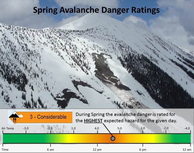
Rating danger for the HIGHEST expected hazard. It’s common to experience melt-freeze conditions with daily swings in temperature from freezing cold nights to hot sunny afternoons. When this regime is established you find thick surface crusts with good corn-snow riding as the sun warms things up. But when the crust melts, avalanche hazard spikes. We will rate the avalanche danger as the HIGHEST expected that day. Elsewhere in the forecast you’ll find more information about when, where, and why Danger Ratings may be lower (for example, because of a strong overnight re-freeze, crusts are unlikely to break down until late afternoon) and provide ideas for how to manage your avalanche risk (for example, start early and be out of avalanche terrain by noon). The danger-ratings alone will provide sound advice for minimally trained people; however, for those with better training, more experience, and greater skills, the Danger Ratings may seem too conservative. So make sure you look further than a quick scan of the Danger Rating colours.
Four Spring Scenario Guides. Once we see consistent long-term spring conditions for all elevation bands, or we no longer have sufficient snowpack and avalanche observations to issue danger ratings, our forecasts will provide a spring conditions statement with a link to four Spring Scenario guides:
Avalanche danger may be variable, ranging from Low to High as conditions change. Rapid changes are possible due to solar radiation, daytime warming, or rain. Pay careful attention to the thickness and strength of surface crusts, and how they break down during the day. Travelling early in the day is generally recommended.
Here are the four spring scenario guides:
Cold and Snowy: when winter storms roll through
Daily Melt-Freeze Cycles: Warm during the day, cold overnight
All Melt, No Freeze: Intense warming with no overnight re-freeze
All Freeze, No Melt: Cool weather with little or no melting
Each scenario has specific weather, snowpack, and avalanche characteristics. Each has trip planning advice. And each requires a different approach in terms of risk management. It’s up to you to decide which scenario applies to your specific location and situation. To figure this out you will have to look at past weather, the weather forecast, and get as much local information as possible from knowledgeable people in your area.
Remember that in the spring strong solar radiation and warm temperatures can weaken the snow in a matter of minutes, and danger can change from LOW to HIGH very quickly. Be alert to changing conditions and be prepared to adjust your travel plans accordingly.