- Date
- Thursday, December 30, 2021
An update on the lasting impact of the atmospheric rivers
Part 1: A frozen river
One month ago, the stream of atmospheric rivers that flooded parts of British Columbia came to an end. When temperatures subsequently cooled, the mountains of southern BC and Alberta were left covered by a thick crust that extended into the alpine. At that point we were unsure how this crust would impact future conditions. Over the last month, we’ve developed an understanding on how this problem has evolved.
Part 2: Spotty problems emerge
As snow began accumulating in early December, weak faceted snow formed above the crust in some, but not all, locations. What emerged was a spatially variable persistent slab problem. Words like “spotty”, “patchy”, and “spooky” were used to describe problematic areas.
Persistent slab avalanches have been observed over the past few weeks in most forecast regions, including the Sea to Sky, South Coast Inland, North and South Columbias, Kootenay-Boundary, Purcells, Lizard-Flathead, and South Rockies. The most evident pattern was that the majority of avalanches occurred around treeline elevations, between 1,700–2,100 m depending on the region. But there have not really been any other clear trends.
There have not been many periods when avalanche activity on these layers spiked, but rather we’ve seen a handful of large avalanches reported each day. The problem has persisted and our forecasts have featured sustained elevated danger ratings and advised choosing conservative terrain to manage this problem.
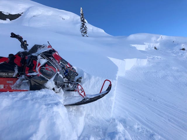
Snowmobile-triggered avalanche in the Sea to Sky region from Dec 20 (MIN report from David Dobson).
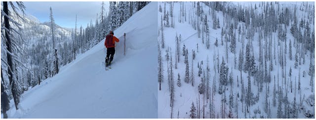
Skier-triggered avalanche in the Columbia Mountains from Dec 26.
Part 3: What to expect next ...
As time passes, this persistent weak layer will gradually strengthen and avalanches will become more difficult to trigger. It will likely become a low-probability, high-consequence scenario.
This is likely already the case in coastal regions, where this layer is buried 100–200 cm deep. We have started to see a declining trend in avalanches, with the most recent avalanches triggered in shallow rocky start zones where the weak layer was closer to the surface. In the interior, where the weak layer is only 50–150 cm deep, notable avalanche activity has continued since Christmas.
In either case, the spotty reactivity of this problem makes it tricky to manage. As an example, we may have 10 slopes that fit the criteria for this avalanche problem, but only see reactivity on one of those slopes, with virtually no indication of which slope it will be.
To manage this problem, one would ideally obtain a strong grasp on its distribution in one’s local area, but this is only really possible with intimate terrain and snowpack knowledge. Realistically, you should exercise patience and be willing to avoid suspect slopes. This requires great discipline, as we will not always experience direct feedback from the avalanche problem and it doesn’t scream “dangerous!” the way a touchy storm slab problem does.
In this case, we can say the most suspect slopes are ones steeper than 35 degrees around treeline elevations. Be especially careful where the layer is buried by less than a metre of snow, or where the snowpack transitions from thick to thin spots. In this terrain, you should exercise good travel habits and keep in mind the potential for large, destructive avalanches.
And, of course, check the avalanche forecast to get the latest recommendations about how this problem is evolving in your region. We wish you a happy and safe New Year!
Simon, Zoe, & The forecasting team

Spotty problems are tough to solve.