- Date
- jeudi 16 décembre 2021
The Last Straw?
TL;DR?
In much of Western Canada, a 50 to 150 cm slab is sitting on top of a crust/facet combo which has produced some surprises over the last few days. Conditions are officially tricky and potentially high consequence. If you’re heading out, making conservative terrain choices and leaving a wider margin for error is essential, here are some strategies AvCan forecaster Josh Smith uses to manage persistent slabs:
- I make more conservative terrain choices and leave myself way more margin for error in my decision making. I reduce the likelihood of triggering the layer of concern by avoiding classic trigger spots in the terrain, such as steep slopes, roll-overs, and spots where the snowpack is shallow or thin to thick.
- I reduce the consequences of being wrong by sticking to smaller pieces of terrain that aren’t capable of creating large avalanches. I also avoid slopes with terrain traps such as cliffs, crevasses, and deep depressions where even a small avalanche can have deadly consequences.
- I find this easy to do for a few days, but when the problem persists for weeks, I find it takes a lot of discipline to not let my desire to push into bigger terrain get the best of me. However, in my experience, patience pays off when you nail that dream line in perfect conditions.
Want to really get into it? Here is the Full Low Down:
How did this persistent slab scenario develop? This problem was created by the atmospheric river event in early December that left a hard surface crust capping the snowpack. After the storm, a weak layer of facets (sugary snow crystals) began to develop above and below the crust. There’s now 50-150 cm above this interface. While there have only been a few avalanches reported on this layer, the ones that we’re seeing are concerning due to their wide propagations. This means, if you do hit the “sweet spot” on the wrong slope, it results in a large destructive avalanche that can connect smaller pieces of terrain.
Here’s why we are concerned. In many of the regions, the cohesive slab of snow on top of this layer has been building slowly; something we refer to as “incremental loading”. It seems to be coming into its own right now, it’s getting just enough cohesion to fail as a slab, and there have been a few different human triggered avalanches in the last few days across the province. They’re sporadic, but they’re spooky avalanches in terrain that isn’t all that threatening at first glance.
Here's an image of an avalanche a skier accidentally triggered in the Cariboo Region on Tuesday December 14:
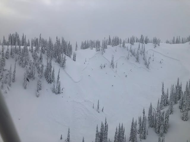
Avalanche in the Cariboo region.
It’s incredibly difficult, if not impossible, to predict exactly how much snow it will take to finally tip the balance and really bring this problem to life. Is it the next storm that overloads this weak layer, leading to numerous natural and human triggered avalanches? It might be. Or is it one of us moving through the terrain that becomes the proverbial “straw that breaks the camel’s back”?
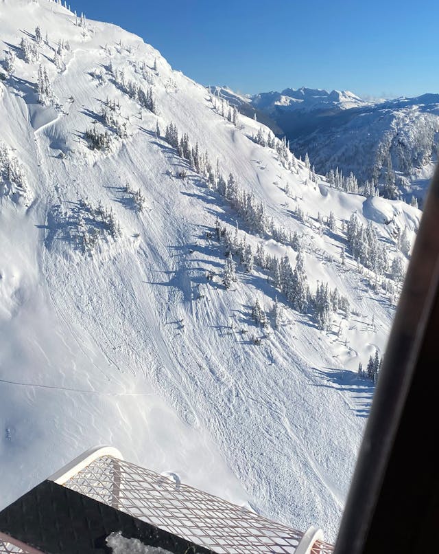
Image of an avalanche a skier accidentally triggered in the Sea to Sky Region on Thursday December 16. Photo: Michael Cooperberg
The storm forecast to impact much of the province this weekend is looking like it's going to wallop the coast, and then dry out as it moves inland, producing more moderate snowfall amounts in the interior and Rockies.
Video from the Nahatlatch area, South Coast Inland. Credit: Harrison Lake Heliskiing
You will see elevated danger for regions where significant snow is forecast, but the ratings may not look so bad across the board. However, it’s important to remember that even a moderate danger rating means: “large human-triggered avalanches are possible in isolated areas.” Danger ratings are helpful for getting an overview, but to get the whole picture, you’ve got to dig deeper than the danger rating– this is especially important when dealing with the kind of condition that currently exists.
The real “meat and potatoes” of an avalanche forecast are the avalanche problems. When we’re out in the mountains sledding or ski touring, avalanche problems are at the forefront of our minds. Here’s what we think about:
- What are the current avalanche problems?
- Where in the terrain are we likely to find them?
- How likely are we to trigger them?
- How big will the avalanche be if we do trigger it?
For example, when the danger is rated moderate and the only avalanche problem is a storm or wind slab, we treat the mountains very differently than when the danger is rated moderate and there is a persistent slab problem. Storm or wind slabs are way more predictable than persistent slabs. We have a lot more uncertainty about the snowpack when dealing with persistent slabs. This makes recognizing and managing or avoiding persistent slabs a much more complex challenge.
The only real option at times like this is to scale back and adopt a conservative approach.
As the next weather systems roll in, continue to watch the forecasts where we’ll keep you updated on how this situation is evolving.
Josh Smith & Grant Helgeson
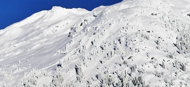
Another view of the avalanche a skier accidentally triggered in the Sea to Sky Region on Thursday December 16. Photo: Ken Bibby